18 millas de miradores desde el anfiteatro hasta Rainbow Point: cada parada merece la pena
La ruta escénica de Bryce Canyon es una sola carretera de 18 millas que baja desde la entrada del parque hasta Rainbow Point, a 9,115 pies. Todos los miradores y senderos principales salen de está carretera. Puedes recorrerla en menos de una hora sin parar, pero la idea es parar: las vistas cambian a medida que avanzas hacia el sur, desde el anfiteatro lleno de hoodoos cerca de la entrada hasta panoramas de largo alcance al final.
Si solo tienes un par de horas, céntrate en los miradores del anfiteatro en las primeras tres millas. Si tienes un día completo, combina la ruta con una caminata y sigue hasta los miradores más tranquilos, donde muchos visitantes nunca llegan.
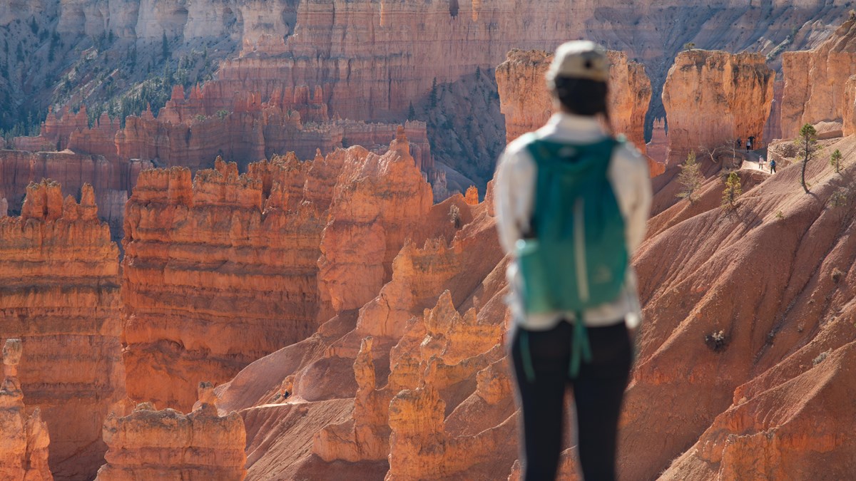
The amphitheater viewpoints (first 3 miles)
These four viewpoints overlook the Bryce Amphitheater — the largest and most famous concentration of hoodoos in the park. They are all within a short drive or walk of each other, and you can connect them on the paved Rim Trail.
Sunrise Point - Elevation: 8,100 ft. The northernmost amphitheater viewpoint with a 360-degree panorama. You look down into Queen's Garden and across the full width of the amphitheater. Despite the name, this spot is good for both sunrise and sunset. Trailhead for the Queen's Garden trail.
Sunset Point - Elevation: 8,000 ft. The most popular viewpoint in the park. Thor's Hammer — the park's most-photographed hoodoo — stands directly below the railing. Trailhead for the Navajo Loop. Best lighting in early morning when the sun hits the hoodoos head-on.
Inspiration Point - Elevation: 8,100 ft. A slightly higher vantage that takes in the full sweep of the amphitheater. Less crowded than Sunset Point and arguably a better overall view. Three tiers of overlook, with the upper level offering the widest panorama.
Bryce Point - Elevation: 8,300 ft. The southernmost and highest amphitheater viewpoint. Considered by many to be the best overall view in the park. You see the full amphitheater below and can look north to the other viewpoints. Trailhead for the Peek-a-Boo Loop and Under the Rim trails. Start here if arriving early.
South of the amphitheater (miles 3—18)
Past the amphitheater, the road climbs south through ponderosa and fir forest to a series of overlooks that most day visitors skip. The formations are different here — arches, bridges, and long-distance views instead of dense hoodoo fields. Each stop is uncrowded and feels more remote.
Fairyland Point - technically north of the amphitheater (a spur road before the fee station), but often missed. Quiet views of the Fairyland Canyon and the starting point for the Fairyland Loop.
Swamp Canyon - a small overlook with views into a side canyon. Trailhead for the Swamp Canyon connecting trail. Quick stop, good for a leg stretch.
Piracy Point & Farview Point - two overlooks close together with expansive views south and east. On clear days you can see over 100 miles. Named for the geological "stream piracy" visible in the drainage patterns below.
Natural Bridge - a natural arch (technically not a bridge — it was carved by weathering, not water) framing the forested canyon below. One of the most photographed features along the southern drive. Quick pullover, easy viewing from the parking area.
Agua Canyon & Ponderosa Canyon - side-by-side viewpoints with towering hoodoos that rival the amphitheater. The Hunter formation at Agua Canyon is one of the tallest freestanding hoodoos in the park.
Rainbow Point & Yovimpa Point - the end of the road at 9,115 feet — the highest point in the park. Two overlooks here: Rainbow Point faces east with views of the Grand Staircase, and Yovimpa Point faces south with layered sedimentary cliffs stretching to the horizon. The Bristlecone Loop (1 mile, easy) starts here and passes ancient trees over 1,800 years old.
Which stops to prioritize
If you have 1-2 hours, stay in the amphitheater area. Start at Bryce Point, then drive to Sunset Point and Sunrise Point. Walk the paved Rim Trail between them.
If you have 3-4 hours, add the drive south. Stop at Natural Bridge, Agua Canyon, and Rainbow Point. Do the Bristlecone Loop at Rainbow Point before heading back.
If you have a full day, combine the scenic drive with the Queen's Garden and Navajo Loop hike. Drive to Rainbow Point first while parking is easy, hike the amphitheater trails late morning, and walk the Rim Trail in the afternoon.
The shuttle or your car?
The free park shuttle (April—October) covers only the amphitheater area — it loops between the shuttle station, the Visitor Center, Sunrise, Sunset, Inspiration, and Bryce Points. It runs every 15 minutes from 8 AM to 6 PM (extended to 8 PM in summer).
For the amphitheater viewpoints in peak summer, the shuttle is the easiest option. Parking lots fill by mid-morning and the shuttle drops you at each viewpoint without circling for spots. For the southern viewpoints (Natural Bridge, Rainbow Point), you need your own vehicle — the shuttle does not go there.
Vehicles over 20 feet are restricted from the amphitheater parking areas during shuttle season. If you are driving an RV or pulling a trailer, park at the shuttle station and ride in.
Consejos desde Duck Creek
Drive south first, amphitheater second. Most visitors hit the amphitheater viewpoints immediately, so the southern road is empty in the morning. Drive to Rainbow Point while it is quiet, then return to the amphitheater when the early rush has passed.
Morning light for photography. The amphitheater faces east — morning sun lights up the hoodoos directly. By afternoon the amphitheater is in shadow. Rainbow Point, facing east and south, also looks best in the morning.
Pair with Mossy Cave on the way back. The Mossy Cave trailhead is on UT-12 between the park and US-89, right on your route back to Duck Creek. It is a free 30-minute hike with its own hoodoos and a seasonal waterfall.
Fuel up before you go. There are no gas stations inside the park. Fill up in Duck Creek, Hatch, or Panguitch on your way.
Stay planning
A scenic drive day at Bryce pairs naturally with a hiking day at Zion or a closer outing to Cedar Breaks. Use Plan Your Days to build a multi-day itinerary from Duck Creek Village Inn. Compare our rooms and cabins to find the right fit — three national parks are within day-trip range.
March 2026
Por qué confiar en está guía
Recorremos está carretera con regularidad y escribimos desde la perspectiva de huéspedes que hacen una excursión de un día desde Duck Creek Village. El acceso a los miradores y los horarios del shuttle cambian según la temporada: revisa siempre los recursos del NPS antes de ir.
La carretera principal del parque mide 18 millas en una dirección, desde la entrada hasta Rainbow Point. Con paradas en los miradores principales, calcula 2 a 3 horas para hacerla ida y vuelta. Puedes acortar el recorrido si regresas después de los miradores del anfiteatro, que están en las primeras 3 millas.
¿Cuáles son los mejores miradores en la ruta escénica de Bryce Canyon?
Los cuatro miradores del anfiteatro, Sunrise Point, Sunset Point, Inspiration Point y Bryce Point, son los más populares y dramáticos. Más al sur, Natural Bridge y Rainbow Point son más tranquilos y valen la pena si tienes tiempo.
¿Necesito el shuttle para la ruta escénica?
No para hacer las 18 millas completas. El shuttle gratuito, de abril a octubre, solo cubre la sección del anfiteatro. Para los miradores al sur de Bryce Point necesitas tu propio vehículo. En horas punta de verano, el shuttle es una buena forma de visitar el anfiteatro sin preocuparte por estacionar.
¿Se puede hacer la ruta escénica en bicicleta?
No por la carretera principal, pero el sendero multiuso de 5 millas conecta la estación del shuttle con el centro de visitantes, Sunrise Point, Sunset Point e Inspiration Point. Se pueden alquilar bicicletas estándar y eléctricas en la antigua estación de servicio del parque.
¿Cuál es la mejor hora del día para la ruta escénica?
La mañana y la última tarde ofrecen la mejor luz para fotos. El anfiteatro mira al este, así que el sol de la mañana golpea directamente los hoodoos. Si llegas temprano, empieza por Bryce Point y sube hacia el norte; si vas más tarde, conduce primero al sur hasta Rainbow Point y vuelve por el anfiteatro cuando haya menos gente.
Quédate aquí y conduce Bryce mañana
Reserva tu habitación o cabaña en Duck Creek Village Inn: cerca de la entrada del parque y sin tráfico.