
Buchen Aufenthalt buchen
Direkt buchen & 10% sparen: Code 10% sparen · bis 1. Dez. · Aufenthalte bis 1. Dez. 2026
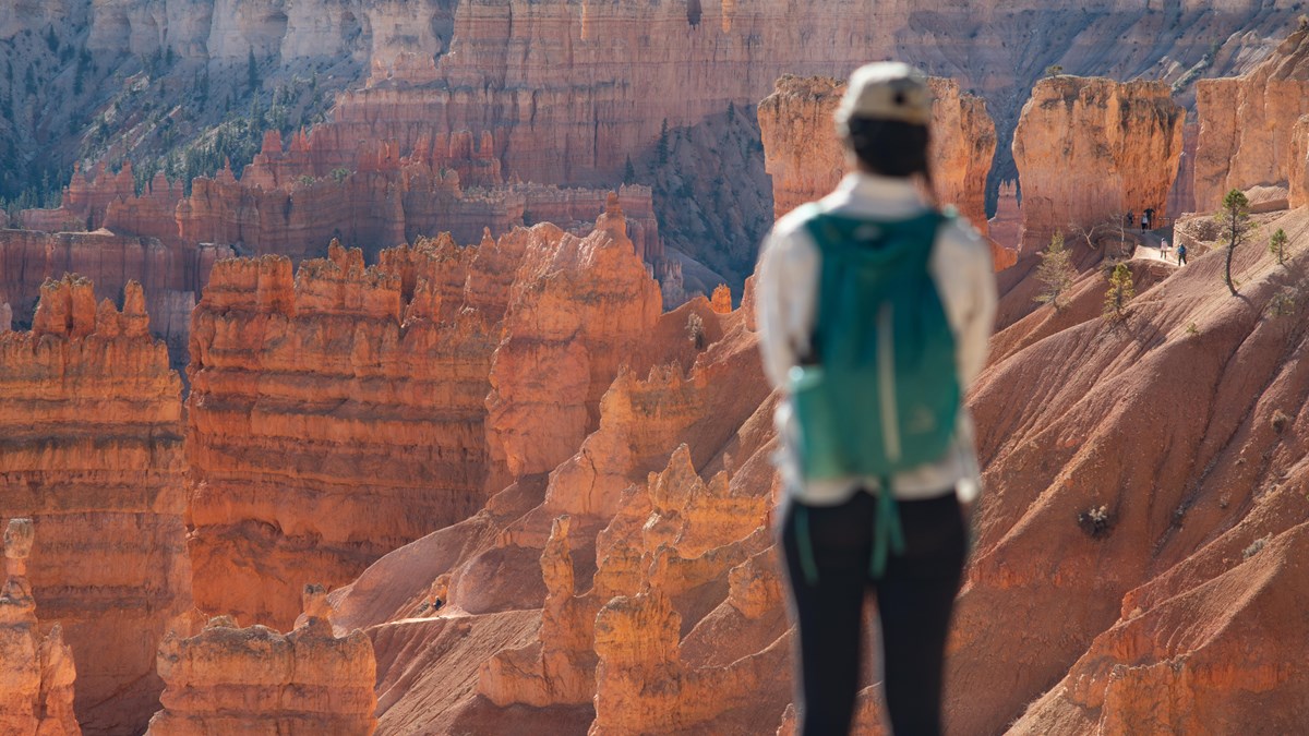
Blick von einem Bryce-Canyon-Aussichtspunkt entlang der Scenic Drive mit Hoodoos und fernen Mesas

Duck-Creek-Guide

Bryce Canyon Scenic Drive

18 Meilen Aussichtspunkte vom Amphitheater bis Rainbow Point - jeder Stopp lohnt sich

Auf einen Blick

Total length
18 miles (29 km) one way, entrance to Rainbow Point. It is a dead end, so 36 miles round trip
Southern Scenic Drive
The 15 miles (24 km) from Mile 3 to the road’s end, with nine overlooks
Highest point
Rainbow and Yovimpa Points, 9,115 ft (2,778 m), the highest viewpoints in the park
Visitor Center
7,894 ft, so the drive gains roughly 1,200 ft as you head south
Drive time, no stops
About 40 minutes each way from the Visitor Center
Realistic time
2 to 3 hours for the drive plus viewpoints; a full day if you add a hike

Die Bryce-Canyon-Scenic-Drive ist eine einzige Straße, die 18 Meilen südlich vom Parkeingang bis Rainbow Point auf 9.115 Fuß führt. Jeder wichtige Aussichtspunkt und jeder Trailhead zweigt von dieser Straße ab. Du kannst sie ohne Stopps in unter einer Stunde fahren, aber der Sinn ist das Anhalten - die Ansichten verändern ihren Charakter, je weiter du nach Süden fährst, von den dichten Hoodoos im Amphitheater nahe dem Eingang bis zu weiten Panoramen am Straßenende.

Wenn du nur ein paar Stunden hast, konzentriere dich auf die Amphitheater-Aussichtspunkte in den ersten drei Meilen. Wenn du einen ganzen Tag hast, kombiniere die Fahrt mit einer Wanderung und fahre weiter nach Süden zu den ruhigeren Aussichtspunkten, die viele Tagesgäste nie erreichen.

How the road is laid out

Miles 1 through 3 hold the Bryce Amphitheater, the dense hoodoo bowl everyone comes for, plus the park shuttle, the lodge, both campgrounds, and nearly all the parking pressure. From Mile 3 south, the road becomes what the park calls the Southern Scenic Drive: 15 quieter miles climbing through ponderosa and fir to nine overlooks, most of them a few steps from the car.

The character changes as you climb. The amphitheater is about looking down into a forest of hoodoos. The southern overlooks are about looking out: over the Paria Valley, across the stepped cliffs of the Grand Staircase, and on clear days to Navajo Mountain more than 80 miles away.

Die Amphitheater-Aussichtspunkte (erste 3 Meilen)

Diese vier Punkte blicken auf das Bryce Amphitheater - die größte und berühmteste Hoodoo-Konzentration des Parks. Sie liegen nahe beieinander, und du kannst sie auf dem gepflasterten Rim Trail verbinden.

Sunrise Point - Höhe 8.100 Fuß. Der nördlichste Amphitheater-Aussichtspunkt mit 360-Grad-Panorama. Blick in den Queen's Garden und über die ganze Breite des Amphitheaters. Trotz des Namens gut für Sonnenauf- und -untergang. Trailhead für Queen's Garden.

Sunset Point - Höhe 8.000 Fuß. Der beliebteste Aussichtspunkt im Park. Thor's Hammer - der meistfotografierte Hoodoo - steht direkt unter dem Geländer. Trailhead für den Navajo Loop. Morgens am besten, wenn das Licht direkt auf die Hoodoos fällt.

Inspiration Point - Höhe 8.100 Fuß. Höherer Blickwinkel mit vollem Amphitheater-Sweep. Weniger voll als Sunset Point und vielleicht der insgesamt bessere Blick. Drei Ebenen, die oberste mit dem weitesten Panorama.

Bryce Point - Höhe 8.300 Fuß. Der südlichste und höchste Amphitheater-Punkt. Viele halten ihn für den besten Gesamtblick im Park. Du siehst das ganze Amphitheater und blickst nach Norden zu den anderen Aussichtspunkten. Trailhead für Peek-a-Boo Loop und Under-the-Rim-Trails. Wenn du früh da bist, starte hier.

Südlich des Amphitheaters (Meilen 3-18)

Hinter dem Amphitheater steigt die Straße südlich durch Ponderosa- und Tannenwald zu einer Reihe von Aussichtspunkten an, die die meisten Tagesgäste auslassen. Die Formationen sind hier anders - Bögen, Brücken und Fernblicke statt dichter Hoodoo-Felder. Jeder Stopp ist ruhig und wirkt abgelegener.

Fairyland Point - technisch nördlich des Amphitheaters (ein Abzweig vor der Fee-Station), aber oft übersehen. Ruhige Blicke in den Fairyland Canyon und Startpunkt des Fairyland Loop.

Swamp Canyon - kleiner Aussichtspunkt mit Blick in ein Seitental. Trailhead für den Swamp-Canyon-Connect-Trail. Schneller Stopp, gut zum Beinevertreten.

Piracy Point & Farview Point - zwei nahe beieinander liegende Punkte mit weitem Blick nach Süden und Osten. Bei klarer Sicht über 100 Meilen. Benannt nach der geologischen "Stream Piracy" in den Abflussmustern unten.

Natural Bridge - ein natürlicher Bogen (technisch keine Brücke - durch Verwitterung, nicht Wasser, geformt) rahmt das bewaldete Tal unten ein. Eines der meistfotografierten Motive an der Südrute. Schneller Pullover, gut vom Parkplatz aus sichtbar.

Agua Canyon & Ponderosa Canyon - nebeneinanderliegende Aussichtspunkte mit hohen Hoodoos, die dem Amphitheater Konkurrenz machen. Die Hunter-Formation in Agua Canyon ist einer der höchsten frei stehenden Hoodoos im Park.

Rainbow Point & Yovimpa Point - das Straßenende auf 9.115 Fuß, der höchste Punkt im Park. Zwei Aussichten hier: Rainbow Point blickt ostwärts auf die Grand Staircase, Yovimpa Point nach Süden auf geschichtete Sedimentklippen bis zum Horizont. Der Bristlecone Loop (1 Meile, leicht) startet hier und führt an über 1.800 Jahre alten Bäumen vorbei.

Welche Stopps priorisieren?

Wenn du 1-2 Stunden hast, bleib im Amphitheater-Bereich. Starte am Bryce Point, fahre dann zu Sunset Point und Sunrise Point. Geh zwischen ihnen auf dem gepflasterten Rim Trail.

Wenn du 3-4 Stunden hast, nimm die Südrute dazu. Halt an Natural Bridge, Agua Canyon und Rainbow Point. Mach bei Rainbow Point den Bristlecone Loop, bevor du zurückfährst.

Wenn du einen ganzen Tag hast, kombiniere die Scenic Drive mit der Queen's-Garden-/Navajo-Loop-Wanderung. Fahr zuerst nach Rainbow Point, solange das Parken einfach ist, wander spät vormittags unten im Amphitheater und geh nachmittags auf dem Rim Trail.

Light, timing, and where the crowds are

The amphitheater faces east, so morning is when the hoodoos are lit head-on and glowing. By mid-afternoon the bowl falls into its own shadow and the color flattens. That argues for the same plan as the traffic does: south early, amphitheater when you get back.

The park does not publish a single "best" sunset overlook, but it does say Paria View, facing southeast toward the White Cliffs and Navajo Mountain, is wonderful at sunset, and Bryce Point’s southern angle holds light late. Both Sunrise and Sunset Points were named as marketing, not as astronomy, and the park says plainly that each is spectacular at either end of the day.

Parking is the real constraint, not the road. Sunset Point has 115 spaces and Sunrise 113, and both fill on summer mornings. Agua Canyon has seven. If you arrive at a full lot in the amphitheater, take the shuttle instead of circling; if you arrive at a full lot in the south, drive on and catch it on the way back.

Winter and shoulder season

The park never closes, and the main road is plowed. What happens after a storm is that the road beyond Mile 3 closes temporarily while crews clear the higher southern section, usually for a day or more, depending on how much fell. The amphitheater stays reachable; Rainbow Point may not be.

Two spur roads close for the whole season once snow removal begins: the 1-mile road to Fairyland Point and the 0.3-mile road to Paria View. Both stay open to skiers and snowshoers, which is why the park closes them. Everything else on the drive stays drivable between storms.

Underfoot is the other winter story. The park warns that popular trails and even parking lots and paved areas get icy enough that steep sections cannot be crossed safely without traction devices. Bring microspikes if you plan to walk anything beyond the railing. Check today’s Bryce conditions before you leave, and our road-conditions page for the drive over Cedar Mountain.

Shuttle oder eigenes Auto?

Der kostenlose Park-Shuttle (April bis Oktober) deckt nur den Amphitheater-Bereich ab - er fährt zwischen Shuttle Station, Besucherzentrum, Sunrise, Sunset, Inspiration und Bryce Point. Tagsüber kommt er alle 15 Minuten von 8 Uhr bis 18 Uhr (im Sommer bis 20 Uhr verlängert).

Für die Amphitheater-Aussichtspunkte in der Hochsaison ist der Shuttle die einfachste Option. Parkplätze werden bis zum späten Vormittag knapp, und du wirst an jedem Punkt ohne Parkplatzsuche abgesetzt. Für die südlichen Punkte (Natural Bridge, Rainbow Point) brauchst du dein eigenes Auto - der Shuttle fährt dort nicht hin.

Fahrzeuge über 20 Fuß sind während der Shuttle-Saison aus den Amphitheater-Parkbereichen ausgeschlossen. Wenn du einen RV oder Trailer fährst, parke an der Shuttle-Station und fahre mit.

How the day flows from Duck Creek

  1. Bryce is about an hour from Duck Creek Village Inn, south on UT-14 to US-89 and east on UT-12. A workable summer day looks like this:
  2. 7:00 AM: Leave the inn with a full tank; fill up in the village before you drop off the mountain.
  3. 8:00 AM: Through the entrance and straight past the amphitheater turnoffs. Do not stop yet.
  4. 8:45 AM: Rainbow and Yovimpa Points. Walk the Bristlecone Loop while the air is still cold.
  5. 10:00 AM to 12:30 PM: Work north: Black Birch, Ponderosa, Agua Canyon, Natural Bridge, Farview and Piracy, Swamp Canyon. Every one a right turn.
  6. 12:30 PM: Lunch at the lodge or from the cooler at a picnic table.
  7. 1:30 PM: Amphitheater: Bryce Point, Inspiration, Sunset, and the paved rim walk to Sunrise.
  8. 4:00 PM: Mossy Cave on UT-12 on the way out, if anyone still has energy.
  9. 5:30 PM: Back at Duck Creek Village Inn, 8,400 feet and about twenty degrees cooler than the valley.

Practical details

Entrance fee
$35 per vehicle for 7 days, $30 motorcycle, $20 on foot or bike; America the Beautiful pass accepted. The park is cashless, cards only
International visitors
Non-US residents aged 16 and up pay a $100 nonresident fee on top of the entrance fee, unless admitted with an Annual or America the Beautiful pass
Fuel
Fill up before you go. The park’s own services run to a lodge, a general store and two campgrounds, not a gas station
Altitude
Around 8,000 ft through the amphitheater, over 9,000 ft at the south end; take the first day easy
Restrooms on the drive
Visitor Center, Sunset Point, Farview Point, and Rainbow Point
Dogs
Paved surfaces and paved viewpoints only, 6-foot leash, never on the shuttle, and never at Piracy Point
Bikes
A 5-mile shared use path links the Shuttle Station to the Visitor Center, Sunrise, the lodge, Sunset and Inspiration Point; e-bikes under 750 W allowed, and the shuttle carries two bikes

Aufenthaltsplanung

Ein Scenic-Drive-Tag in Bryce passt natürlich zu einem Wandertag in Zion oder zu einem näheren Ausflug nach Cedar Breaks. Nutze Plane deine Tage, um ein Mehrtagesprogramm ab Duck Creek Village Inn zu bauen. Vergleiche unsere Zimmer und Cabins, um das Richtige zu finden - drei Nationalparks liegen in Tagesausflugs-Reichweite.

August 2026

Warum diesem Guide vertrauen

Wir fahren diese Straße regelmäßig und schreiben aus der Perspektive der Gäste, die einen Tagesausflug ab Duck Creek Village machen. Zugang zu Aussichtspunkten und Shuttlepläne ändern sich saisonal - vor dem Besuch immer die NPS-Quellen prüfen.

Fragen zur Scenic Drive

Häufige Fragen von Reiseplanern.

How long does the Bryce Canyon scenic drive take?

About 40 minutes each way from the Visitor Center to Rainbow Point if you never stop. With the viewpoints, the National Park Service suggests 2 to 3 hours for the round trip. Add a hike at either end and it becomes a full day. The road is 18 miles one way and dead-ends, so you drive 36 miles total.

Can I tow a trailer on the Bryce Canyon scenic drive?

Yes. The Southern Scenic Drive is open to all vehicles, including rigs over 23 feet, and every viewpoint from Swamp Canyon south to Rainbow Point has oversized parking. The restriction is in the amphitheater: during shuttle season, vehicles 23 feet and longer cannot park at the Visitor Center, Sunrise, Sunset, Inspiration or Bryce Points, or the lodge, between 8 a.m. and 8 p.m. (8 a.m. to 6 p.m. in April and October). Paria View bans oversized vehicles year-round. The simplest plan is to drop the trailer at the Shuttle Station in Bryce Canyon City, the additional Visitor Center lot, or your campsite, then drive south unhitched.

Is the Bryce Canyon scenic drive open in winter?

Yes. The park is open year-round and the main road is plowed. After a snowstorm the road beyond Mile 3 closes temporarily, usually a day or more, while crews clear the higher southern section, so the amphitheater stays reachable when Rainbow Point may not. The 1-mile Fairyland Point spur and the 0.3-mile Paria View road close for the whole season once plowing begins, and stay open to skiers and snowshoers. Check the NPS current conditions page the morning you go.

Does the Bryce Canyon shuttle go to Rainbow Point?

No. The free shuttle covers only the amphitheater area (Shuttle Station, Visitor Center, lodge, campgrounds, and Sunrise, Sunset, Inspiration and Bryce Points) on a roughly 50-minute loop with buses about every 15 minutes. There is no service on the Southern Scenic Drive, and the three-hour Rainbow Point bus tour is not being offered. You need your own vehicle for everything past Mile 3. In 2026 the shuttle runs April 3 to October 18, with hours that change by month.

Which direction should I drive the Bryce Canyon scenic drive?

Drive straight to Rainbow and Yovimpa Points first, then take the viewpoints on the way back north. That is the National Park Service’s own recommendation: on the return every overlook is on the right-hand side, which the park calls much safer than pulling across traffic. It also puts you at the quiet southern end early and back in the amphitheater after the first morning rush.

What are the best viewpoints on the Bryce Canyon scenic drive?

For hoodoos, the four amphitheater overlooks in the first three miles: Bryce Point for the widest view from the south, Inspiration Point for its three tiers over the Silent City, Sunset Point for Thor’s Hammer, and Sunrise Point at 8,100 feet. Heading south, do not skip Natural Bridge at Mile 12.25, Agua Canyon at Mile 13.5 for The Hunter, and Rainbow and Yovimpa Points at the end, where the view runs more than 100 miles across the Grand Staircase.

Hier übernachten, morgen Bryce fahren

Buche dein Zimmer oder deine Cabin im Duck Creek Village Inn - etwa eine Stunde vom Parkeingang entfernt mit kühlen Bergabenden und kaum Verkehr.

10% Rabatt direkt mit Code · Aufenthalte bis 1. Dez. 2026 Bester Preis direkt · Jetzt reservieren, später zahlen

Anrufen · 435-990-5488