Moab sits about 290 road miles from Duck Creek Village, a drive of five to six hours by way of US-89 and I-70. The village is the highest ground of the whole trip, Moab lands 4,400 feet lower, and one stretch of I-70 runs about 104 miles with no services.
How Far Is Duck Creek Village From Moab? 290 Miles, and a Long Way Down
Moab sits about 290 road miles from Duck Creek Village, Utah. The fastest route runs east on Highway 14, north on US-89 through Panguitch, east on I-70 across the San Rafael Swell, and south on US-191 into town. Our routing puts the drive at 5 hours 20 minutes without stops, so plan on five to six hours door to door.
That makes Moab a travel day from the village, not a day trip. Round trip you would cover about 580 miles and spend 11 hours in the car for an afternoon among the arches. Treat Moab as the next stop on a Utah parks loop and give it its own nights.
| Duck Creek Village to Moab | Details |
|---|---|
| Road distance | About 290 miles |
| Driving time | 5 to 6 hours with a fuel stop |
| Main route | SR-14, US-89, I-70, US-191 |
| Elevation change | 8,440 ft down to about 4,030 ft |
| Time zone | Same, Mountain Time |
The route east from Duck Creek Village
You leave the village going downhill. Highway 14 drops about 10 miles to Long Valley Junction, where you turn north on US-89. From there the road follows the Sevier River valley through Panguitch, Circleville and Junction before it meets I-70 near Sevier at exit 23.
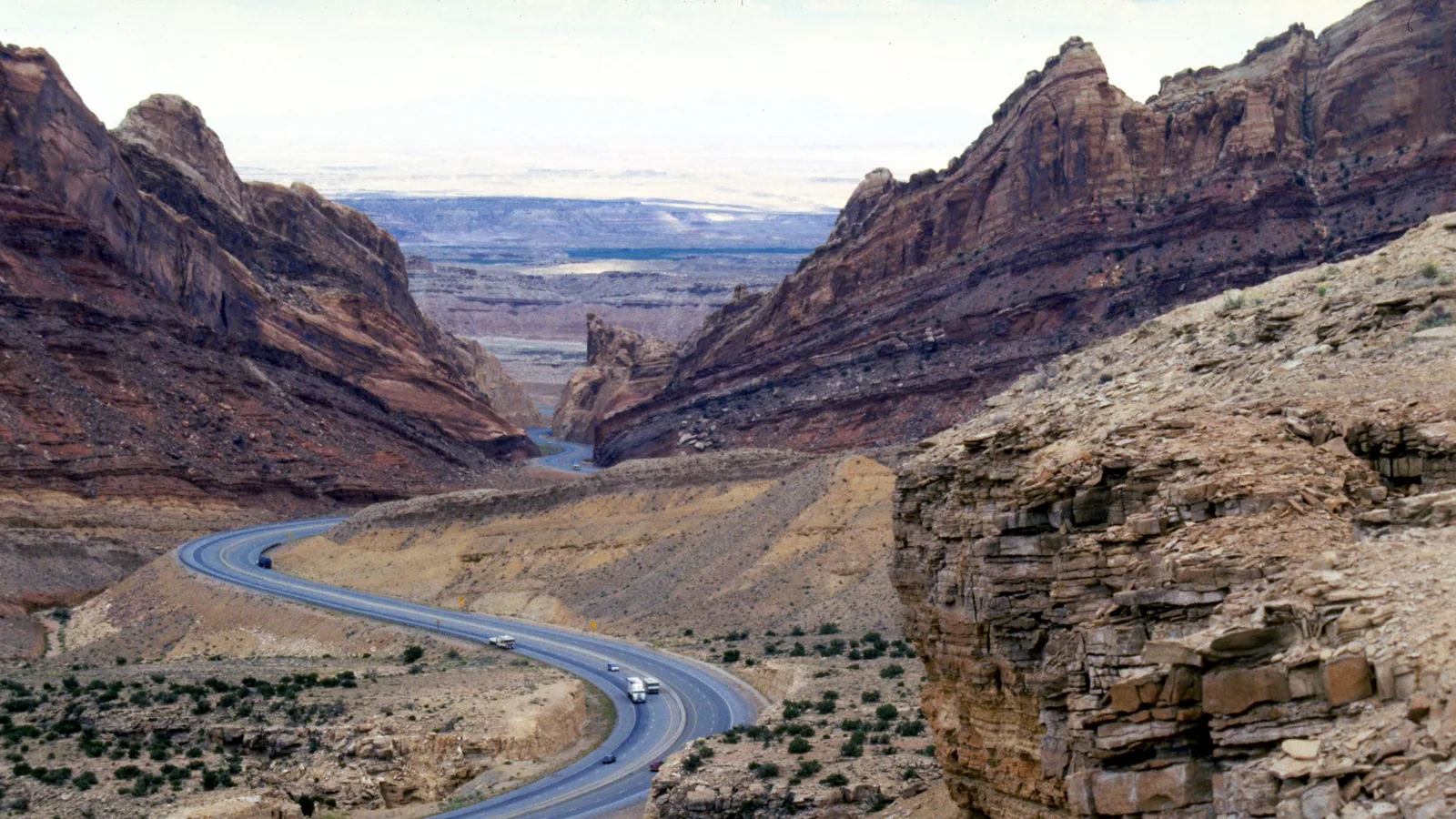
I-70 carries you east past Richfield and Salina. After Salina the interstate climbs the Wasatch Plateau to Emigrant Pass, drops through the San Rafael Swell, and runs out onto the desert flats at Green River. At Crescent Junction you leave the interstate for US-191, and 31 miles later you reach Moab.
| Stop on the drive | Road miles from the inn |
|---|---|
| Long Valley Junction | 10 |
| Panguitch | 39 |
| Richfield | 116 |
| Salina | 135 |
| Green River | 238 |
| Arches visitor center | 286 |
We sampled USGS elevations every two miles along the whole route. The highest ground of the trip is the place you start. The inn sits near 8,440 feet, and nothing on the road to Moab reaches it. Emigrant Pass, the top of I-70 in Utah, stands at 7,886 feet on UDOT maps, about 550 feet lower than the village. Moab lands near 4,030 feet, so you finish about 4,400 feet below your front porch.
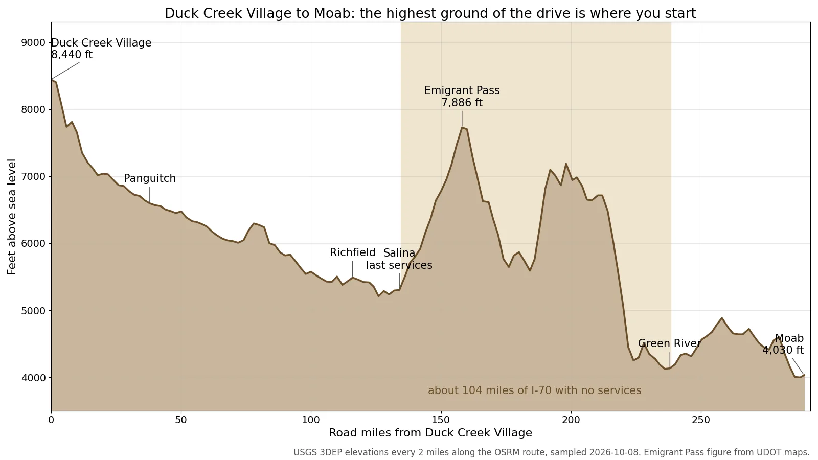 Elevation every two miles along the route, from USGS 3DEP data sampled for this post. The shaded band marks the I-70 stretch with no services.
The 104 miles with no services on I-70
The one part of this drive that needs a plan is fuel. From Salina’s exit 56 to the first Green River exit at 160, I-70 runs about 104 miles with no gas, no food and no towns. The stretch counts as the longest gap in motorist services anywhere on the Interstate system.
The road also works hard through that gap. Out of Salina the interstate gains about 2,500 feet in 30 miles to reach Emigrant Pass, then crosses the Swell through Ghost Rock Summit at 7,405 feet before the long drop to Green River. A car that left the village with half a tank will feel that climb.
Slower routes past Capitol Reef or Highway 12
Two scenic alternatives add a dozen to twenty miles and a lot more time. The first leaves US-89 for SR-62 and SR-24 through Loa and Torrey, crosses Capitol Reef National Park along the Fremont River, and meets I-70 west of Green River after Hanksville. That way runs about 301 miles.
The second goes east on Highway 12 past Bryce Canyon, through Escalante and Boulder, and over Boulder Mountain to Torrey before joining the same road through Capitol Reef. That route comes to about 310 miles of two-lane highway with steep grades and slow towns. Give it a full day and stop often.
Highway 24 through Capitol Reef carries no entrance fee. The park’s $20 vehicle fee covers the Scenic Drive south of the visitor center. Our Grand Circle road trip guide times Capitol Reef to Moab at about three hours, which makes Torrey a good place to break the trip.
Arches and Canyonlands in 2026
| Arches National Park, 2026 | Details |
|---|---|
| Timed entry | Not required in 2026 |
| Vehicle fee | $30 |
| Hours | Open 24 hours, all year |
| Nonresident surcharge | Not charged at Arches |
The Arches entrance comes about four miles before downtown Moab on US-191, at 286 road miles from the inn. Island in the Sky in Canyonlands sits farther out, about 300 miles from the village. The National Park Service says Arches will not require timed-entry reservations in 2026, though parking can still fill and slow the gate at busy times.
If you live outside the United States, one 2026 change matters to you. Bryce Canyon and Zion now add $100 per person for non-U.S. residents 16 and older. Arches, Canyonlands and Capitol Reef do not appear on that list, so a Duck Creek to Moab trip can skip the surcharge on the eastern half.
Weather and daylight on the two ends
| October and November | Moab normals |
|---|---|
| October high | 73.5F |
| October low | 41.7F |
| November high | 57.1F |
| November low | 30.3F |
Moab runs about 14 degrees warmer than the village on an October afternoon. Our October weather post puts normal highs on the mountain at 58 to 60F, while Moab’s 1991 to 2020 normal reaches 73.5F. Pack for both. You may scrape frost off the windshield at the inn and walk around Moab in shirtsleeves that afternoon.
Both places keep Mountain Time, so the clock does not change. The sun does. On October 15 it sets at 6:54 pm in the village and 6:41 pm in Moab, 13 minutes sooner. Leave the village by late morning and you reach town with daylight to spare.
Quick answers about Moab from Duck Creek
Can you visit Moab as a day trip from Duck Creek Village? Not in any comfort. The round trip covers about 580 miles and 11 hours of driving, so book at least one night in Moab.
Do you need a reservation to enter Arches in 2026? No. The National Park Service says Arches does not require timed-entry reservations in 2026, and the vehicle fee runs $30.
Which park sits closer to the village, Arches or Canyonlands? Arches. Its entrance sits about 286 road miles from the inn, and the Island in the Sky visitor center sits about 300.
Where should you get gas on the way to Moab? Fill up in the village and again in Salina or Richfield. I-70 then runs about 104 miles to Green River with no services.
Should you drive back to Duck Creek the same day? Plan the return as its own travel day, or loop back past Capitol Reef and Bryce Canyon with a night on the way. Then end the trip with a quiet night in one of our cabins.
Hero photograph: Interstate 70 in the San Rafael Swell, Dennis Adams, National Scenic Byways Online (FHWA), public domain.