Duck Creek Village sits about 470 road miles from downtown Los Angeles, 8 to 9 hours of driving on I-15 through Las Vegas and Cedar City, then 30 miles up Highway 14. Utah runs an hour ahead of California, and the drive finishes 8,200 feet above where it started.
How Far Is Duck Creek Village From Los Angeles?
Duck Creek Village sits about 470 road miles from downtown Los Angeles, a drive of 8 to 9 hours before you stop for anything. The route runs I-15 north through Barstow, Las Vegas and St. George to Cedar City, then 30 miles east up Highway 14. Utah keeps its clocks an hour ahead of California, so a nine hour day lands ten hours later by the time you pull in.
| The short answer | |
|---|---|
| Road distance | About 470 miles |
| Driving time | 8 to 9 hours |
| Route | I-15 to Cedar City, Highway 14 east |
| Start and finish elevation | 289 ft to 8,507 ft |
| Clock | Utah runs one hour ahead of California |
Those numbers start at City Hall. Anaheim comes in 8 miles shorter at 460, and San Diego runs 530 miles. Almost all of it is interstate, and only the last 30 miles climb a two lane mountain highway.
The drive in legs, from the Inland Empire to Cedar City
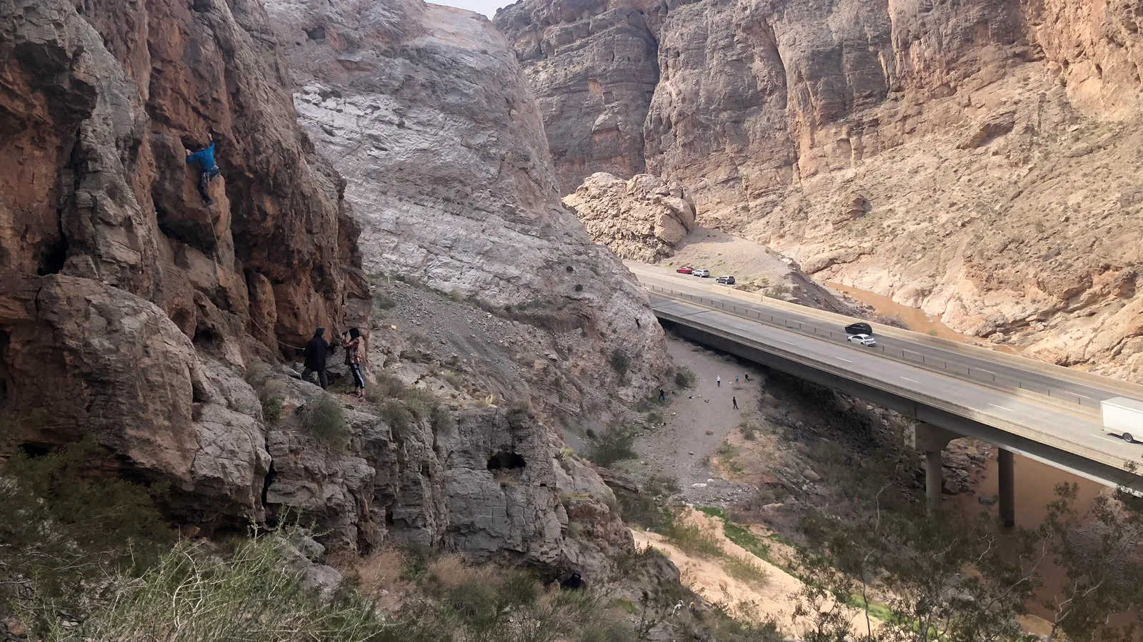
Leaving the basin, I-15 crosses Cajon Summit at 4,190 feet and drops into the Mojave. After Barstow the towns thin out, and Baker sits alone before the long pull up to Mountain Pass. Las Vegas comes in just past the halfway point. North of Mesquite the interstate cuts through 29 miles of Arizona, 11 of them inside the Virgin River Gorge, and climbs out at St. George, the first Utah town on the route.
| Miles from downtown LA | |
|---|---|
| Barstow | 115 miles |
| Baker | 177 miles |
| Las Vegas | 270 miles |
| St. George | 387 miles |
| Cedar City | 438 miles |
Cedar City is the exit that matters. Follow Center Street east, which is Highway 14. It climbs through Cedar Canyon and over the plateau, 30 miles and 45 minutes to our door. Our Cedar City distance guide covers that last stretch turn by turn, including the crest just before the village.
A second route exists through Zion. Leave I-15 at the Hurricane exit, run through Springdale and the Zion tunnel, then come up US-89 to Long Valley Junction and Highway 14 west. It adds only 17 miles to the trip. It also adds a $35 park pass, since the National Park Service requires one even to drive through, plus canyon traffic and the tunnel size limits. It makes a fine first day of the trip and a slow way to get there.
The climb hides in the last thirty miles
We sampled USGS elevations every four miles along the route, and the profile looks nothing like the map. Two desert passes, a long run near 2,000 feet through Nevada, and then Highway 14 stands up in one wall at the end.
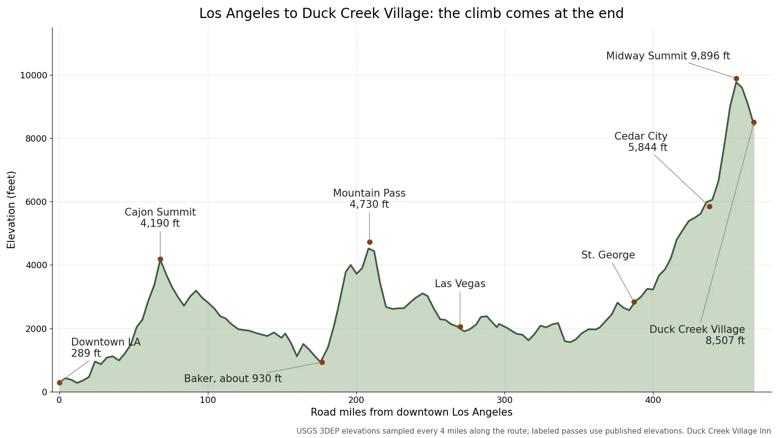
Elevation along the Los Angeles to Duck Creek Village route, sampled every four miles from the USGS 3DEP public domain elevation service. Chart by Duck Creek Village Inn.
| Elevation along the way | Feet |
|---|---|
| Cajon Summit | 4,190 |
| Near Baker, the low point | About 930 |
| Mountain Pass | 4,730 |
| Cedar City | 5,844 |
| Midway Summit on Highway 14 | 9,896 |
Mountain Pass stands as the highest point of the drive until Utah, and by the end of the day it counts as a foothill. From Cedar City the road gains more than 4,000 feet in 20 miles, crests at Midway Summit, then drops 1,400 feet into the village. The highest ground of the whole drive sits nine miles short of the door. An engine without a turbo gives up about 3 percent of its power per 1,000 feet, so a loaded car that cruised the desert will work on that grade. Our SR-14 road conditions page shows the cameras before you commit.
Two climates on the same day
The weather at the two ends of this drive shares little in fall, and packing from a Los Angeles forecast is the classic mistake.
| October normals | High and low |
|---|---|
| Downtown Los Angeles | 78.6F / 59.9F |
| Duck Creek Village elevation | 58 to 60F / 33 to 34F |
Look at the downtown number on the right. The normal October overnight low in Los Angeles runs as warm as the normal October afternoon high up here. About a dozen October nights on the mountain reach freezing, so bring a real jacket, a warm layer for the evening, and closed shoes. Our October weather guide breaks down the month week by week.
Coming home on a Sunday afternoon
Southbound I-15 narrows to two lanes after it crosses into California, and Sunday afternoons near Primm back up 10 miles or more on many weekends with weekend traffic from Las Vegas. That choke point sits about 240 miles from the village. Leaving at dawn gets you through ahead of the Vegas crowd, and a Monday departure skips it altogether.
The train will not solve this for a few years yet. Brightline West plans 218 miles of track from Las Vegas to Rancho Cucamonga, and in January 2026 it set a new completion target of late 2029. Even then, Duck Creek sits 200 miles past the Las Vegas station. Flying makes sense for some families, and our airport guide compares Las Vegas, St. George and Cedar City. For more ideas on shaping the trip from Southern California, see our Los Angeles trip planner.
Quick answers about driving from Los Angeles
How long does the drive from Los Angeles to Duck Creek Village take? Plan on 8 to 9 hours of driving for about 470 miles, plus stops. Add one more hour to the clock, since Utah runs ahead of California.
Can I drive through Zion on the way from Los Angeles? Yes, and it adds about 17 miles. You pay the $35 Zion vehicle pass even to pass through, and the tunnel has size limits for RVs and trailers.
What time zone is Duck Creek Village in? Mountain Time, one hour ahead of California all year. The 29 miles of I-15 in Arizona match California until November 1 and match Utah after that.
Is there a train from Los Angeles toward Duck Creek Village? Not yet. Brightline West targets late 2029 for service between Rancho Cucamonga and Las Vegas, which still leaves 200 miles of driving.
How far is Duck Creek Village from San Diego? About 530 road miles on the same I-15 route, so a longer day than Los Angeles by an hour or more.
With the drive mapped out, our cabins in the heart of Duck Creek Village make the next step.
Hero photograph: Interstate 15 at the west entrance of the Virgin River Gorge, Arizona, by RandomAmericanTeen, CC0 via Wikimedia Commons.