Book Book Your Stay
Book direct & save 10%: code Save 10% · stays thru Dec 1 · stays through Dec 1, 2026
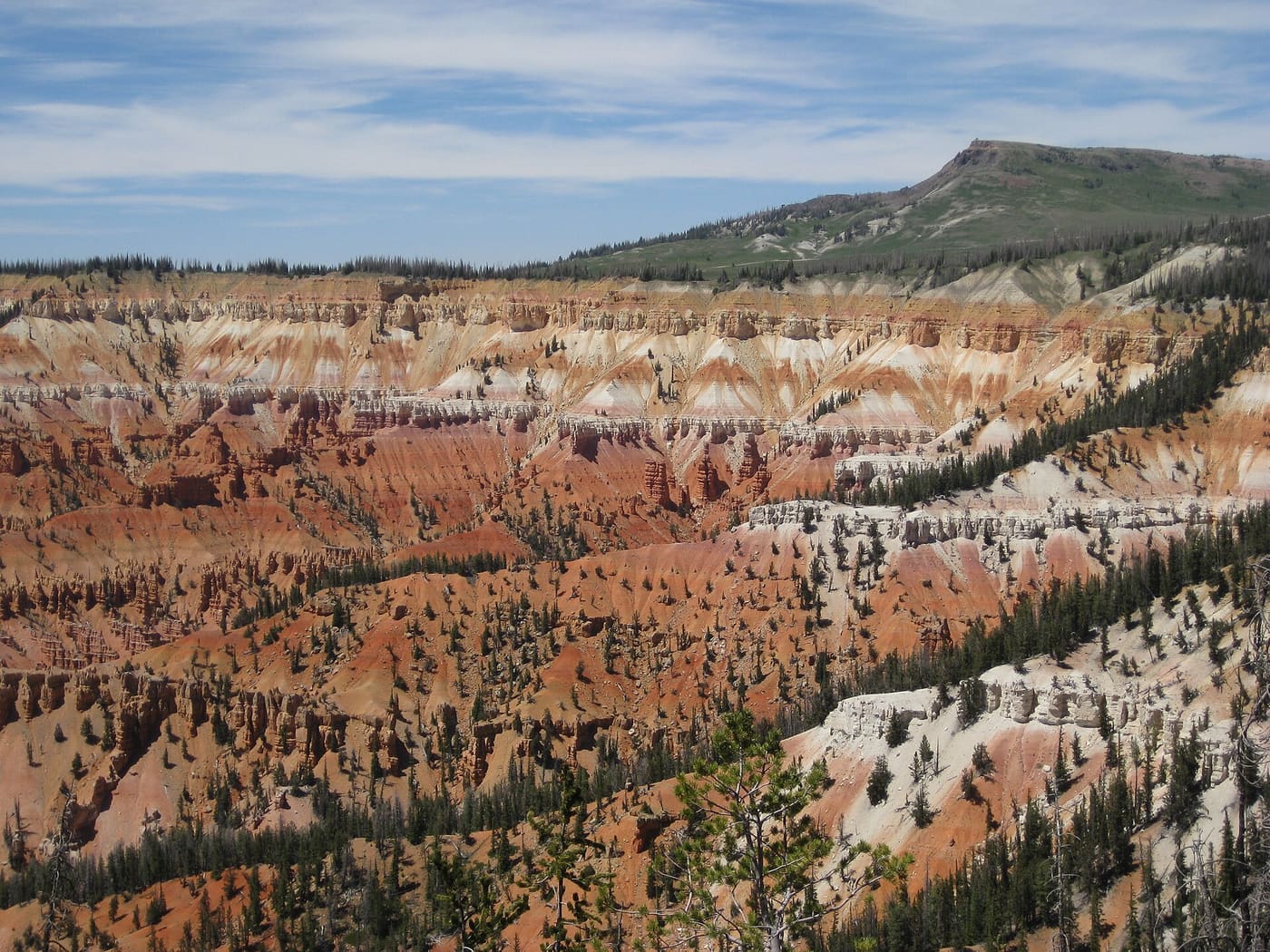
The Cedar Breaks amphitheater in summer with Brian Head Peak on the skyline, the summer route to Brian Head

Duck Creek Guide

Getting to Brian Head

Two drives from Duck Creek depending on one gate, measured drive times from everywhere guests start, the canyon traction law, and the cameras to check before you leave.

At a glance

From Duck Creek, summer
23.5 mi, about 41 min over the Cedar Breaks rim on SR-14 and SR-148
From Duck Creek, winter
About 1 hr 15 (35.2 mi) by Mammoth Creek Road and SR-143 when that road is passable; 1 hr 35 min (61.2 mi) by Cedar City and Parowan, the guaranteed route
Traction law
SR-143 up Parowan Canyon is a Class II segment: when active, every vehicle needs snow tires, M+S on all four, or chains
The climb
Parowan Canyon gains 3,946 ft in 15.7 mi; the steepest two miles average 9.9 percent
Live cams
5 UDOT cameras on SR-143 from the Parowan side over the top to Panguitch Lake, refreshed every minute
Nearest airports
Cedar City (CDC) 35 mi; St. George (SGU) 85 mi; Las Vegas (LAS) 201 mi; Salt Lake City (SLC) 246 mi

This is the single thing worth understanding before you plan a Brian Head day from Duck Creek. There are two drives, and which one you get depends entirely on whether Highway 148 through Cedar Breaks is open. From anywhere else in the region there is only one road in, Highway 143 up Parowan Canyon, and in winter it is the one road in from Duck Creek too.

From Duck Creek: the summer hop and the winter loop

In summer it is a short, spectacular hop: Highway 14 west from the village, north on Highway 148 through Cedar Breaks National Monument, then Highway 143 into town. 23.5 miles, about 41 minutes, and you cross the Cedar Breaks rim at 10,601 ft on the way, higher pavement than any lift base at the resort. If you have never done it, budget extra time, because you will stop.

The interactive map needs JavaScript. In summer the route is SR-14 west, SR-148 north through Cedar Breaks, then SR-143 into Brian Head. In winter the usual way is Mammoth Creek Road north to SR-143 and west over the top when that county road is passable; the guaranteed way is SR-14 down to Cedar City, I-15 north to Parowan, then SR-143 up Parowan Canyon.

  • Summer route, over Cedar Breaks
  • Winter when passable, Mammoth Creek Road (county road, not guaranteed)
  • Winter guaranteed, around by Parowan
  • Resort base area
  • Where the summer road closes
All three drives from the inn to the Giant Steps base, on real road geometry. The dashed line is Mammoth Creek Road, the way we usually go when it is passable; the long loop by Cedar City is the one you can always count on.

Around mid November the National Park Service gates Highway 148 for winter and it does not reopen until mid or late May. The guaranteed drive then becomes Highway 14 down to Cedar City, I-15 north to Parowan, and Highway 143 back up Parowan Canyon: 61.2 miles and about 1 hr 35 min in good conditions. You lose 4,200 ft of elevation to the valley floor and climb 3,950 ft back up in the final thirteen miles. Cumulatively the winter route makes you climb 5,954 ft against the summer route’s 2,476.

Elevation profiles of the summer and winter drives from Duck Creek Village Inn to Brian Head Both drives start at the inn at 8,426 feet and end at the Giant Steps base area near 9,750 feet. The summer route is 23.5 miles and crosses the Cedar Breaks rim at 10,601 feet. The winter route is 61.2 miles: over the Highway 14 summit, down to 5,632 feet in Cedar Valley, north on the interstate, then back up nearly 4,000 feet through Parowan Canyon. 6,000 7,000 8,000 9,000 10,000 Inn10 mi20 mi30 mi40 mi50 mi60 mi SR-14 summit 9,890 ft Cedar Valley floor 5,632 ft Parowan the climb starts Cedar Breaks rim 10,601 ft Brian Head 9,752 ft
  • Summer 23.5 mi · 41 min · 2,476 ft of climbing
  • Winter 61.2 mi · 1 hr 35 min · 5,954 ft of climbing
The same two drives in cross-section, USGS 3DEP elevations sampled every 500 metres. In summer you go over the top; in winter you have to go all the way down to the valley floor and climb back.
Leg by leg, in good conditions
Leg Road Miles Time
Summer: 23.5 mi, 41 min
Inn to the SR-148 junctionRolling plateau forest, climbing about 1,450 ft to the turn. In winter the plowing on SR-148 stops right here. SR-14 west 12.3 18 min
Junction to Point SupremeInto Cedar Breaks past the visitor center. You are on the rim at 10,350 ft, and the highest pavement of the day is still ahead. SR-148 north 3.2 7 min
Cedar Breaks to Brian HeadOver the top of the rim road at 10,601 ft, past the Brian Head Peak turnoff, then down into town. SR-148 to SR-143 north 8 16 min
Winter: 61.2 mi, 1 hr 35 min
Inn down to Cedar CityOver the SR-14 summit at 9,890 ft, then 4,200 ft down through Cedar Canyon. The descent is the part that needs your attention in winter. SR-14 west 29.8 46 min
Cedar City to ParowanThe only flat, fast, plowed-first stretch of the whole drive. I-15 north 18.9 23 min
Parowan up to Brian HeadParowan Canyon: 3,950 ft of climbing in 13 miles, with a two-mile stretch near the top that averages almost 10 percent. This is the Class II traction-law segment. SR-143 south 12.5 26 min

There is a middle way, and it is the one we usually take. Mammoth Creek Road runs north from the village to Highway 143 near Panguitch Lake, and Highway 143 then climbs west over the top into Brian Head: about 35.2 miles and an hour and a quarter in winter. The catch is that Mammoth Creek Road is a county road, plowed but not guaranteed. It drifts shut after storms and can be closed for days, so check it the morning you go (the SR-143 cameras below show the Panguitch Lake end) and treat the Cedar City loop as the route you can always count on. A high-clearance vehicle with real snow tires is the sensible way to try it.

Parowan Canyon and the traction law

Parowan Canyon is the part that deserves respect. Highway 143 climbs 3,946 ft in 15.7 miles from the valley, the steepest sustained two miles average close to ten percent, and UDOT classifies it as a Class II traction-law segment, a step above Highway 14. When UDOT activates the law there, four-wheel drive alone is not enough: a two-wheel-drive car needs tires with the three-peak mountain snowflake symbol, an all- or four-wheel-drive vehicle needs M+S tires on all four corners, and anything else needs chains. The statewide minimum tread is 2/32 inch; the 5/32 rule people quote belongs to the Cottonwood Canyons and does not apply here.

Highway 14 from Cedar City to Duck Creek, by contrast, is a Class I segment, where the law applies to vehicles over 12,000 pounds. Passenger cars are not legally required to carry chains there, which is a point our own winter driving page makes at length; we still recommend snow tires for the whole plateau from November to April.

UDOT plows Highway 143 during daylight hours, and the NPS puts it plainly: snow tires or chains are required on Highway 143 generally from November 30 to March 1. The live strip below carries UDOT’s surface condition and restriction for the “Parowan to Brian Head” segment when its feed is up, and the winter driving guide explains what the categories mean.

Drive times from where you start

OSRM routes at posted speeds to the Giant Steps base, traced October 2026. Good-conditions figures; storms, holiday traffic and the plow in front of you add to all of them.

Drive times to Brian Head Resort (Giant Steps base)
From Miles Time Route and notes
Duck Creek Village Inn (winter, when Mammoth Creek Road is passable) 35.2 1 hr 15 min Mammoth Creek Road, SR-143 via Panguitch LakeThe way we usually go. County road, plowed but not guaranteed; it drifts shut after storms. OSRM says 68 min at posted speeds; call it 1 hr 15 on snow. 23.5 mi / 41 min in summer over Cedar Breaks.
Duck Creek Village Inn (winter, guaranteed route) 61.2 1 hr 35 min SR-14, I-15, SR-143 via ParowanAll state highways, plowed first. The route to take after a storm or if Mammoth Creek Road is closed.
Parowan 12.6 26 min SR-143 up Parowan CanyonThe only winter approach. Class II traction road; 3,900 ft of climb in 13 miles.
Cedar City 31.3 48 min I-15 north to Parowan, SR-143Last big grocery, gas and chain stop. Cedar City Regional Airport is 35 miles out.
Panguitch 35.7 54 min SR-143 past Panguitch LakePlowed in winter, but a higher, lonelier road than the Parowan side. Check the SR-143 cams.
Bryce Canyon (visitor center) 60.7 1 hr 32 min SR-63, US-89, SR-143 via PanguitchThe ski-plus-hoodoos combination; both are over 8,000 ft, so pack for the same weather.
Zion east entrance 69.6 1 hr 47 min SR-9, US-89, SR-14 or I-15, SR-143Winter routing goes down to Cedar City and back up through Parowan.
St. George 85 1 hr 40 min I-15 north, SR-143 at ParowanThe closest commercial airport with daily flights (SGU). Expect a 7,000 ft climb and a 30-degree temperature drop.
Springdale (Zion south) 87.7 1 hr 52 min SR-9 west, I-15 north, SR-143Skip the Zion tunnel; the interstate is faster in winter.
Las Vegas 201 3 hr 43 min I-15 north through the Virgin River Gorge, SR-143 at ParowanAbout 3 hr 45 in good conditions. Rental fleets run all-season tires; see the traction rules below.
Salt Lake City 245.5 4 hr 23 min I-15 south, SR-143 at ParowanAbout 4 hr 25. Brian Head is the southernmost Utah resort and usually the earliest to open.

Live SR-143 cameras

UDOT’s five cameras on Highway 143, in order from the Parowan side over the top to the Panguitch Lake side. Images refresh every minute while you keep this page open. The Brian Head road page adds a 24-hour rewind under each camera and the map.

  • UDOT traffic camera: SR-143 @ Milepost 13.43 (Parowan side)

    SR-143 @ Milepost 13.43 (Parowan side)

  • UDOT traffic camera: SR-143 @ Brian Head / Milepost 18.19

    SR-143 @ Brian Head / Milepost 18.19

  • UDOT traffic camera: SR-143 @ Milepost 21.91

    SR-143 @ Milepost 21.91

  • UDOT traffic camera: SR-143 @ Milepost 25.13

    SR-143 @ Milepost 25.13

  • UDOT traffic camera: SR-143 @ Milepost 31.14 (Panguitch side)

    SR-143 @ Milepost 31.14 (Panguitch side)

The Cedar Breaks amphitheater in summer with Brian Head Peak rising on the skyline behind it
The summer route runs along this rim. Brian Head Peak is the high point on the skyline; the road closes under the first big snow. brewbooks · CC BY-SA 2.0 · via Wikimedia Commons

Or do not drive it twice

For a ski weekend the winter loop makes the best argument for sleeping at the top of the canyon. The condo we co-host sits across the road from Giant Steps; drive up once, ski two days, drive down once.

October 2026

Why trust this guide

Both Duck Creek routes are OSRM routing lines sampled against USGS 3DEP every 500 metres (September 2026); the origin table is OSRM at posted speeds (October 2026). Traction classes are read from UDOT’s Traction Law Summary Sheet map; the tire rules are Utah Administrative Code R920-6. The seasonal closure dates and the November 30 to March 1 tire note are the National Park Service’s. Camera images are UDOT’s keyless public feeds.

Brian Head drive questions

The road questions that decide whether the day happens.

How far is Brian Head from Duck Creek Village?

23.5 miles and about 41 minutes in summer over Highway 148 through Cedar Breaks. Once that road closes in mid November it is about 35 miles and 1 hr 15 by Mammoth Creek Road and Highway 143 when that road is passable, or 61.2 miles and about 1 hr 35 min by the guaranteed loop through Cedar City and Parowan.

How far is Brian Head from Cedar City?

31.3 miles and about 48 min: I-15 north to Parowan, then Highway 143 up the canyon. Cedar City is the last big grocery, gas and chain stop.

How far is Brian Head from Las Vegas and St. George?

Las Vegas is 201 miles and about 3 hr 45 by I-15 through the Virgin River Gorge; St. George is 85 miles and about 1 hr 40. Both turn off I-15 at Parowan.

Do I need chains or 4WD to get to Brian Head?

When UDOT activates the traction law on Highway 143 (a Class II road), every vehicle needs either 3PMSF snow tires (2WD), M+S tires on all four (AWD and 4WD) or chains. 4WD on all-season tires does not satisfy it. The NPS says tires or chains are generally required November 30 to March 1. Carry chains in a rental car.

Is the road to Brian Head open in winter?

Highway 143 from Parowan is plowed in daylight hours and is the year-round way in. Highway 148 through Cedar Breaks, the summer shortcut from Duck Creek, closes around mid November and reopens mid to late May. Check the UDOT strip and the cameras on this page before you leave.

Can I drive from Duck Creek to Brian Head via Mammoth Creek Road and Panguitch Lake in winter?

Often, and it is the route we usually take: Mammoth Creek Road north to Highway 143, then west over the top, about 35 miles and an hour and a quarter. But Mammoth Creek Road is a county road that is plowed without any guarantee; it drifts shut after storms and can be closed, so check it the morning you go and fall back to the Cedar City and Parowan loop (61 miles, 1 hr 35) when in doubt.

Where are the Brian Head webcams?

The resort’s slope cameras are on brianhead.com. The road cameras are UDOT’s five SR-143 cams shown on this page and, with a 24-hour rewind, on our Brian Head road conditions page.

The Other Way to Beat the Drive

Sleep across the road from the lift in the condo we co-host, or make Duck Creek Village Inn your base and drive up on the clear day.

10% off direct with code · stays through Dec 1, 2026 Best rate direct · Reserve now, pay later

Call Us · 435-990-5488