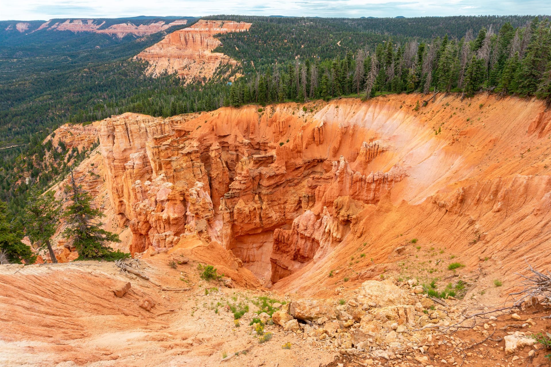
Seven miles of gravel, a five-minute walk, and the widest view into Zion country on the plateau
Strawberry Point is where the Markagunt Plateau ends. You drive seven miles of gravel through aspen and spruce, park at a small lot, walk out a few minutes through the trees, and the ground simply stops: pink and orange hoodoos fall away under your feet, the Virgin River rim runs off to the west, and the country to the south drops toward Zion in a series of cliffs and benches that are hard to take in on the first look. It is the best view on the mountain, and the only one that comes with a real edge.
That edge is the whole story of visiting well. There are no railings, the last stretch of rock narrows to a foot or so, and the drop is a hundred feet in the friendly spots and several hundred in the others. Go in good light, keep kids by the hand, and give it the respect you would give a national park rim. Do that and it is a half-day that people remember for years.
At a glance
Drive from the inn
About 25 minutes: 3.5 miles east on Highway 14, then 7 miles of graded gravel
Elevation
About 9,200 ft at the overlook
The walk
Under 5 minutes from the parking area, then rock and dirt to the edge
Road season
Dry summer and fall; muddy in spring, unplowed and closed by snow in winter
Vehicle
Any car in dry weather; high clearance after rain or early in the season
Facilities
Small lot, no water, no reliable restroom
Fees
None
Best light
Late afternoon into sunset; mornings for photographs of the hoodoos
Getting there
From the inn, head east on Highway 14 for about three and a half miles, past the Duck Creek Visitor Center, to the signed turn for Strawberry Point Road (Forest Road 058) on the south side of the highway; the Forest Service measures the turn at 32.6 miles from Main Street in Cedar City, four and a half miles east of the visitor center. Follow the road roughly seven miles to its end. It is graded gravel the whole way, with a few short rocky pitches and one long stretch through aspen that turns gold in late September.
In dry weather a normal car handles it at an easy pace; allow about 20 minutes for the gravel and drive it like you mean to keep your windshield. After rain, or for a week or two after the snow goes, the road ruts up and turns greasy, and the higher stretches hold snow well into spring. If it has rained in the last day, or if the visitor center says the road is soft, wait. Nothing about the view is worth a tow bill out here, and cell service on the road is patchy at best.
The road is also the Forest Service's spur 58 on the Markagunt OHV system, so expect side-by-sides on summer weekends and give them room on the blind corners. Uinta Flat, the free designated dispersed camping area covered in our camping guide, sits along Forest Road 064 just off the same road.
What you are looking at
The rock under the overlook is the Claron Formation, the same pink limestone that makes Cedar Breaks and Bryce Canyon, and it erodes the same way: fins, windows, and hoodoos in every shade from cream to rust, dropping into a natural amphitheater directly below the point. That is the foreground, and it is why photographers come.
Lift your eyes and the plateau edge runs west along the Virgin River rim, cliff after cliff, toward Navajo Lake and the Pink Cliffs. South and southwest the land steps down toward Zion National Park, and on a clear day the view reaches into the park's high country and the plateaus beyond it. The relief between where you stand and the canyon country in the distance is on the order of a mile, which is why the whole scene feels less like an overlook and more like the edge of the map.
When to go
Sunset is the classic. The view faces south and west, so the last hour of light rakes across the hoodoos and lights the cliffs to the west in sequence. Arrive at least 45 minutes before sunset, and remember that the gravel road in the dark is slower than the gravel road in daylight. Bring a headlamp for the walk back.
Mornings are quieter and better for the hoodoos themselves, which sit in shadow at sunset but glow with the low eastern light. Morning is also the safe choice in July and August, when afternoon thunderstorms build over the plateau most days. A cliff rim at 9,200 feet is the last place to be when lightning moves in; do the exposed walk first thing and be back at the car before the clouds stack up.
Fall is the best of both: the aspens along Strawberry Point Road peak from the last week of September into early October (see our fall colors guide), the road is at its driest, and the air is clear enough that the far cliffs show detail they lose to summer haze. Winter closes the road. It goes unplowed after the first big snow and becomes snowmobile country until late spring; the overlook is reachable by machine when conditions allow, and by nothing else.
The edge, and what to do about it
Strawberry Point has no guardrails, chains, or barriers, and the ground at the lip is decomposing limestone that crumbles underfoot. The walk from the parking area is easy for the first few minutes, then narrows onto rock that in places is a foot or so wide with air on one side. None of that is dangerous if you treat it as what it is: a cliff. Most of the trouble people get into here comes from backing up for a photo.
Small kids: a hold-hands-the-whole-time place. Stop where the trees end if your group has anyone who cannot be trusted at an edge.
Dogs: on a short leash, or leave them in the car for the last stretch. Dogs do not read cliff edges.
Wind: the rim funnels it. On a gusty afternoon, kneel or sit for photos rather than standing at the lip.
Footing: shoes with grip, not sandals. The pale rock near the edge is loose and rounded.
Lightning: if you can hear thunder, you are done. Walk back to the trees and the car.
Rescue: the nearest help is a long way off and cell coverage is unreliable. Tell someone at the inn where you are going.
The Virgin River Rim Trail starts here
Strawberry Point is the eastern end of the Virgin River Rim Trail, a roughly 32-mile route along the plateau edge that is open to hikers, mountain bikers, and horses and closed to motorized use. You do not have to commit to all of it. From the overlook parking the first stretch west along the rim gives you more of the same view without the crowd at the point, and the Cats Den, a second amphitheater of hoodoos, fins, and windows, is one of the trail's named highlights. The Forest Service calls the trail open roughly Memorial Day to Labor Day, with seasonal streams for filtering and no potable water anywhere on it.
The popular through-hike runs from Strawberry Point west to Cascade Falls above Navajo Lake, which needs a car at each end. Our hiking guide covers the trailheads, and the Duck Creek Visitor Center is the place to ask which sections have dried out.
What to bring
Water; there is none at the overlook or on the road
Shoes with grip for the loose rock near the edge
A jacket even in July: the rim is 9,200 feet and windy
A headlamp if you are staying for sunset
A downloaded map; cell service is unreliable on Strawberry Point Road
A wide lens for the amphitheater and a long one for the far cliffs
Making a day of it from the inn
The point pairs naturally with the village side of the plateau. A classic day is Aspen Mirror Lake before nine while the water is still, lunch in the village, Mammoth Cave in the afternoon, then the drive out to Strawberry Point for sunset and a slow, careful drive back for a late dinner. Our Duck Creek day plan lays it out hour by hour, and our rooms and cabins are ten minutes from the turnoff.
September 2026
Why trust this guide
We send guests to Strawberry Point every week of the summer and drive the road ourselves. Directions, facilities, and the OHV spur come from the Forest Service; the elevation from USGS data at the overlook; the notes on the edge and the road in wet weather from our own visits. Roads on the plateau change with every storm, so check the sources below and ask at the visitor center before you go.
How far is Strawberry Point from Duck Creek Village Inn?
About 25 minutes. Drive 3.5 miles east on Highway 14 to the Strawberry Point Road turn, then follow roughly 7 miles of graded gravel to the parking area at the end. The walk from the car to the overlook takes under five minutes.
Can a regular car make it to Strawberry Point?
In dry summer and fall weather, yes; the road is graded gravel and a normal car handles it at an easy pace. After rain or during spring melt it ruts and turns slick, and higher stretches hold snow into late spring. If it rained yesterday, ask at the Duck Creek Visitor Center before you go.
Is Strawberry Point safe for kids?
With care. There are no railings, the rock at the edge is loose, and the drops are a hundred feet and more. Hold hands the whole way out, stop where the trees end if anyone in the group is unsteady, and skip it in wind or when storms are building.
When is the best time to visit Strawberry Point?
Sunset for the view, since it faces south and west, and morning for photographs of the hoodoos, which sit in shadow late in the day. In July and August go in the morning to stay ahead of afternoon lightning. Late September brings fall color to the road in.
Is Strawberry Point open in winter?
The overlook is, but the road is not. Strawberry Point Road goes unplowed after the first big snow and becomes a snowmobile route until late spring. Plan on late May or June at the earliest for a car, later in a heavy snow year.
Are there restrooms at Strawberry Point?
Do not count on one. The Forest Service lists no restroom information and no potable water for the site. The Duck Creek Visitor Center on Highway 14 has porta-potties, and the village has the last real facilities before the gravel.
Stay Ten Minutes From the Turnoff
Book a room or cabin at Duck Creek Village Inn. Sunset at Strawberry Point, then a short drive home to a warm bed instead of a long one to town.